 |
| The Aboriginal name for The Tip |
We had decided last night that we would rise early today to take stock of supplies before proceeding on the last stretch of this portion of our journey, that of going to Cape York. We had travelled some 7000 kilometres to reach here traversing gullies – cliffs and indeed fording a number of rivers some almost deeper than the car – (pic’s to follow)
 |
| Highway to the cape |
Breakfast was completed by 8:30 and yes we were vertical.
We left the camp to head in
a generally northerly direction as that is just where the end goal was.
As we headed out of the camp gate we were once again meet by the bone jarring roads or tracks that we had become used to since leaving the town of Port Douglas.
The trip was only a short one in comparison to other days and was but 14 – 16 kilometres this still however took nearly 1 hour to negotiate through rivers and sand roads.
On arrival at the tip the feeling was hard to express - we had achieved what a number of people just dream about doing. We parked the car, and no for you smart arses out there, they don’t just dream about parking the car, but they dream about reaching the northern most tip of Australia. I almost burst into song but Gill would have probably stopped me and she certainly would not have agreed to help!
 |
| Signage to the Tip of Australia |
Next was the final trek to the tip.
You see, once you park the car you have two mini mountains to traverse. (I think that Mark Morrison would be the only one of you out there who would, like us, stand at the bottom of a mountain and feel excited about the end goal being in sight – mmm just maybe that means that he is stark raving mad as well!) Anyway off we went – Gill with her wonky knee and me with my Aussie hat on. (By the way the hat proved to be a pain in the arse as well because it sure as hell blows as you cover those mountains and a hat does not make the traverse any easier – thanks Gill for suggesting that I take it) As we crossed the mountains, well mini stone hills I guess, there are all these little stone piles.
I think that the objective is to place a stone on them as you pass, god knows for what reason – however I did feel the need to oblige.
On the final decent down to the famous sign we passed a dial that recorded the various distances to places (see photo when it’s posted) god knows again what damn difference that makes to the world but I guess that if you came from say Ireland then it just might be handy to know how far away the Blarney Stone is, sure!
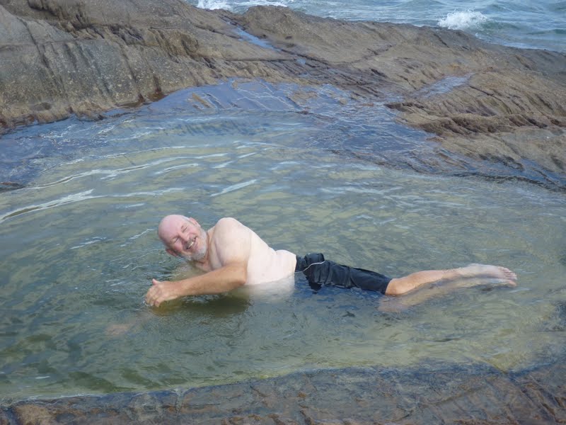
The next stop is where some industrious Australians had planted the Australian Flag – picture opportunity for us and we didn’t even have to carry it – then on down to the final milestone the actual signpost declaring that you had reached the tip. The appropriate photos were taken just before some doofhead decided that he was going to go for a flap in the only rock pool close to the top, damn senile old people
J. (Picture to follow)
Next the return traverse back to where we had parked the car some hour or so prior. We were part way through this traverse when we met up with a group of wandering friends going the other way doing only what can be described as a task of monumental proportions. They were the happiest bunch of people that you could ever hope to come across and you may say what were they doing? Well let me tell you, they were taking their mate to the tip – nothing really special about that apart from the fact that the mate would have weighed about 100 kilos or more, had no legs and was in a wheelchair which they were carrying, wheeling, dragging and using any means of propulsion they could to make his and their dream come true. Now that is what I call a fantastic bunch of good mates. As they passed they asked Gill if she would mind taking some photo’s for them on their cameras which of course she did and they gave their consent for a photo on our camera. Apparently they plan to put a video on U-tube some time.
Okay after the Cape we then decided to see just how many other places we could see on our trip to the top end, so we visited a place called Somerset Bay where we met some others and had lunch with them. Then we went on to explore the beaches/tracks in the area around the bay. Now not to be one not to accept a challenge we went up hill, downhill, through streams and through sand traps until it just became obvious that to carry on any further would have involved needing a pair of pyjamas and waiting for some other fool sometime in the future to come through and rescue us so we turned around and went to Seisia just to have a look around. The road was an official road by the way.
At Seisia we filled the car with diesel $2.24 a litre then went to the port. We made inquiries about shipping the car to Cairns and going as passengers as we thought that this may have been a great experience, however when we found that we would have to buy the boat to do so decided that we would drive. Nearly $2500 for Gill – me and car, even if we had left Gill behind it still would have been $1700.
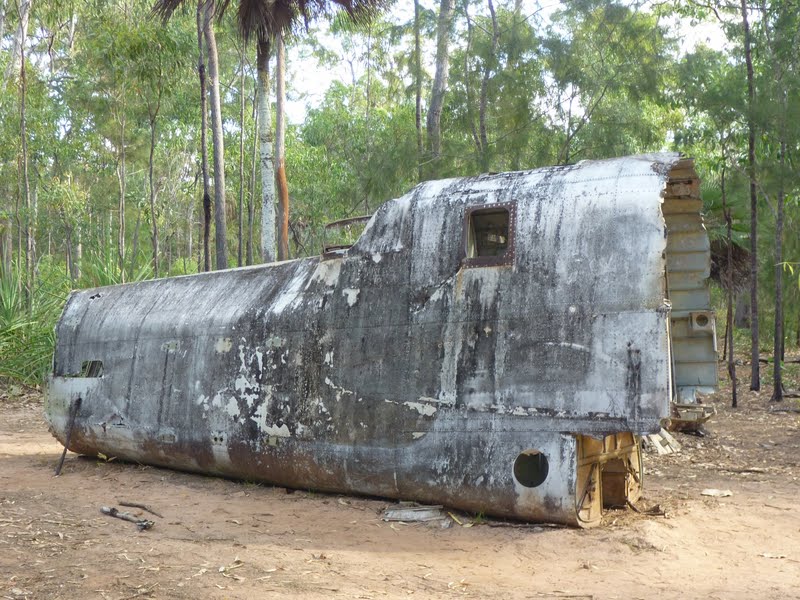
We went out and visited a couple of plane crash sites before returning to camp. One of them was a Japanese plane that had crashed in the 2nd World War and the other a DC3 that had crashed in 1945 on its way to Papua New Guinea. Rather a moving experience to see the way that the locals have preserved one site and not the other, both had contained some ones loved ones.
 |
| State of the road! |
 |
| Road from Punsand to Cape York |
 |
| We have reached the parking at the Tip |
 |
| The tip is the narrow piece - there is a strait before the island |
 |
| Ready to walk to the tip |
 |
| Find the track over the rock face was part of the issue |
 |
| Close up of rocks to Tip |
 |
| How far is it to ...?? |
 |
| Towards the tip - island in background |
 |
| Still a way to go |
 |
| True Australian! |
 |
| We made it to the northern most tip of Australia - Cape York |
 |
| This guy decided to chill off |
 |
| Lighthouse on the island near Cape York |
 |
| Truly there - note SPOT tracking us |
 |
| The trek begins uphill back to the flag |
 |
We met up with this group taking their friend in a wheelchair to the Tip -
they came prepared with the wood to help them over the rocks |
 |
| No legs but still plenty of weight to get up the track |
 |
| They reached the dial which is where we left them |
 |
| Somerset Beach for a lunch stop |
 |
Property on island opposite - they had barge to
come back to mainland |
 |
| Commemoration stone to pioneers |
 |
| The grave was unmarked but still looked after |
 |
| A beach track near Fishy Point |
 |
| Beach view from track near Fishy Point |
 |
| Church in Seisia |
 |
| Ruins of Japanese plane from WWII |
 |
| More ruins of Japanese plane |
 |
| More Japanese plane ruins |
 |
| DC3 plaque |
 |
| DC3 ruins near Bamaga |


Pete what has happened? You sound nearly setimental in that last paragraph!
ReplyDelete